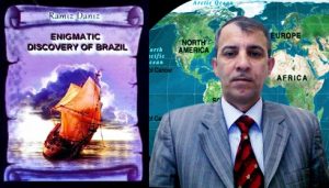
Discovery of Brazil” – The discovery full of enigmas

Most scientists, even the most famous scientists of geography, history of geographical discoveries and history accepted geographical discoveries without investigating some events concerning concrete discovery and such discoveries went down in history as “casual discoveries”. “Casual” discovery of Brazil is obvious case of it.
They explained it as following: two strong currents moving towards west and northeast current existing on the territory between 100 north latitude and 100 south longitude. So vessels might sail to Brazilian coasts involuntarily under the influence of those natural calamities. Was such mistake possible, if Bartolommeo Dias, who could sail from Portugal to the south outskirts of Africa, participated in the expedition? Of course, it wasn’t possible! If such serious mistake was made with participation of Dias, who knew eastern coasts of the Atlantic Ocean very well, how he could reach the Cape of Good Hope located at 10 thousand km away from Lisbon? So questions appear in accordance with that enigmatic discovery. One of main questions: might Cabral make that mistake and change the course according to the secret task of the king of Portugal Manuel I?
Scientists, who support the idea of “casual discovery”, note that three strong currents existed in the middle of the Atlantic Ocean when Cabral sailed to the south. They write that, he had reached Brazilian coasts under the influence of those currents. First of all, let’s analyze directions of mentioned currents.
The North Passat blows from east to west, the equatorial current moves from west to east and the South Passat blows from east to west. The Passat blowing from east to west has also to be mentioned. But in spite of it, scientists use this factor – currents moving towards the west and declare that, Cabral lost his way in the ocean and reached other place. But he might sail there purposely.
Even Duarte Pacheco Pereira could do it without Cabral’s participation.
The leader of the expedition had to be experienced and skilful administrator, but not experienced seaman. He had to establish discipline among seamen and make even the most authoritative seamen to fulfil his tasks unconditio-nally. Professional and authoritative seamen had to fulfil another task. It was the secret task given by the king Manuel I. The staff of the expedition had to prove existence of lands, which were located on western coasts of the Atlantic Ocean, were known by Portugueseand was secret for the world community.
As it was mentioned above, Vasco da Gama also could sail to Brazil under the influence of the equatorial current after changing the route before reaching the equator when sailed towards the south from the Atlantic Ocean in 1497.
If we investigate everything in strict succession, we can see that, there are a lot of obscurities in the discovery of Pedro Cabral. The expedition sailed directly towards the south after leaving San Nicolas Island – one of the central islands of the Green Cape Islands with 12 vessels on March 22. It continued travel towards the west after passing the equator and approached Brazilian coasts at 170 south latitude on April 22. San Nicolas Island is situated at 240 west longitude, Corumba Cape of Brazil is situated at 390 west longitude. It means that, the squadron had moved away from its southern line for 150 towards the west. It is equal to 1600 km at the latitude of Corumba Cape.
It wasn’t possible to make such mistake at the time when the navigation had developed enough. Before this event Portuguese sea travelers had discovered western coasts of Africa during several years, prepared map of those territories and presented it to the monarch of Portugal. Spanish spies observing Cabral’s expedition, well-known navigators, boatswains and captains knew that, 1600 km couldn’t be overcome blindfold after losing way in the ocean. Because vessels usually sail towards the west when there is South Passat. It doesn’t make vessels to lose their ways. Portuguesechanged their route purposely.
Pascual Mountain (536 m) discovered by Cabral is situated at 170 south latitude in the west of Corumba Cape and San Nicolas Island is situated at 160 37/ north latitude.
I.P. Magidovich and V.I. Magidovich write that vessels had to sail 330 30/ towards the latitude of Pascual Mountain and it was equal to about 3700 km.
According to information given by Pero Caminha, navigators had noted in their reports that they had overcome 4000 km. Then it isn’t convincing that, Cabral changed the course directly towards the west after sailing 170 west latitude towards south.
So we may come to the following conclusion: the leader of the expedition wasn’t Cabral at the ocean passage, it was managed by the seaman, who knew that route very well. Otherwise, seamen might meet with difficulties. Because when land isn’t seen for a long time, members of the expedition rise in rebel, demand from admiral and captain to change the course.
The distance between San Nicolas Island and Corumba Cape (together with obstacles occurred in the ocean at the result of currents) is about 4000 km. Vessels sailed only with the south course. The distance was 1600 km at the latitude of Corumba Cape. It isn’t convincing that, vessels lost their way at that latitude and sailed towards the west. Navigators had to understand such mistake. They had compass for manoeuvring in the ocean and determining orientation.
It is absurd to lose way when the compass is available. But it was possible from certain point of view at that time. It is possible to dodge from the fixed course when the weather is so foggy or windy, but this deviation may be 300-400 km or 500-700 km when storm is so heavy. According to diaries of the expedition, Portuguesedidn’t meet any serious natural calamity before passing the equator. It means that, it was impossible to lose way as the weather was good. So Portuguesehadn’t lost their way, they changed the course purposely and sailed to Brazilian coasts with fixed course and discovered mentioned lands. Marine of experienced navigators couldn’t lose its way in the ocean for 1600 km.
As it was mentioned above, experienced captains and commanders as Bartolommeo Dias, Diego Dias, and Duarte Pacheco Pereira were participants of the expedition, these seamen noted the distance they had overcome on their diaries every day and controlled the course of vessels. So they had to understand that the expedition had dodged from the main course and warn Pedro Cabral. But it seems that, the leader of the expedition was satisfied with this deviation and he entrusted his assistants with the course at the ocean passage. In spite of it, the expedition dodged from the main course and sailed in other direction for a long time. But it isn’t convincing argument.
It’s necessary to analyze one important fact. The expedition lost its way in several days after moving away from Green Cape Islands. But Portuguese changed the course towards the Cape of Good Hope located in the south of Africa after leaving “Vera-Crush” “discovered” on May 2. Though they sailed 8000 km, didn’t lose their way and reached the island soon. It means that, Portuguese navigators, who were very skilful in maneuvering in the open ocean, couldn’t reach Brazilian coasts by dodging from the main course when sailed from Green Cape Islands to the Cape of Good Hope. If it happened – if the expedition lost its way and reached Brazilian coasts, it would lose its way when sailed to the Cape of Good Hope as Portuguesesea travelers used that route for the first time.
As it is known, Portuguese met with heavy storm when reached the south of Africa and lost four vessels together with their staffs. It should be especially noted that, Bartolommeo Dias, who had taken the expedition to the south of the Cape of Good Hope, also was the victim of that storm.
It should be noted that, it is possible to determine the geographical latitude continuously when the weather is enough good. How Portuguese could lose the way in that case?
Besides it, Cabral didn’t punish any of his navigators or captains after understanding that the expedition is on the other side of the Atlantic Ocean. Nevertheless such mistake shouldn’t be forgiven at that time. Seamen were surprised. They knew that all tasks of their captains had been fulfilled professionally.
They began to explore the coast as soon as the land was seen. Besides it, Portuguese put big wooden cross on the coast instead of the stone emblem indicating that mentioned territory belonged to the Portugal Kingdom. What it was? It was next negligence or discovered lands weren’t so significant? Nevertheless every sea traveler had to approach such discovery seriously as Portuguese searched for lands on that part of the Atlantic Ocean for tens of years and couldn’t achieve any success. Though Cabral achieved this “happiness”, he was indifferent to his “discovery”.
Why the expedition, which travelled from Lisbon to Calicut, chose strange course? Did Cabral know that other route had been chosen? Apparently, knew. That’s why such negligence had to be punished by him. If that discovery wasn’t important for Portuguese, why did Cabral send one of vessels, which had to sail to India to Lisbon in order to give information about the discovery? It is known that, ten days after the discovery of Brazil the leader of the expedition sent Gaspar de Lemos to Portugal with his vessel and the letter he had written. Information about the discovery was usually sent hastily when discovered geographical point had special importance. It means that, the discovery of Brazil had been planned beforehand and the world community had to be informed about it.
But who had to take the marine to Brazilian coasts, Bartolommeo Dias, who knew half of the way or other person who knew that route very well?
President grant holder on literature, laureate of the “Golden pen” award Ramiz Daniz
A piece from book Enigmatic discovery of Brazil