
Ilanly Mountain and Hacha Mountain in the territory of Nakhchivan


Nakhchivan is located in the range of the Lesser Caucasus Mountains and is located in the area divided between East and West!
Nakhchivan is the bearer of the memory of very ancient histories!
The territory of Azerbaijan was recognized as the territory of “Ur” before the World Flood and in the stages after the World Flood.
In many name carriers the expression “Ur” is used either at the beginning of the word, or in the middle of the word, or at the end of the word, which is characterized as a sign of territorial name carriers!
In the yalli genre, such as the ”Urfani“ yalli, the village ”Urud” in the present Sisian territory, located in the Caucasus mountain range, which is the territory of ancient Azerbaijan, The wind musical instrument “Zurna” (trumpet), the name of the territory of ancient Azerbaijan Urartu, etc.
However, the territory of salvation from the World Flood on the eve of His Holiness Noah’s salvation from the flood with the people of that time in the territory of Ur in that area was dated in many heavenly books and transferred from generations to generations from history to history!
The second name of that salvation territory took its place in the Annals in historical sources also as Noah Chixan (“Noah’s salvation”) so that to save in history the territory of Noah’s salvation from the waters and his salvation!
It is very interesting and very thought-provoking that in the ancient chronicles geographers, historians and travelers in all their writings mentioned a lot of historical information about Nakhchivan, about this area!
As a historical source, those historical writings are still used today as a reference!
The second interesting aspect is that in the historical sources, in The Chronicles compiled in those days, many warlords had military processions to the territory of Azerbaijan, especially to the territory of Nakhchivan!
The Mongol Khans, the processions of Alexander The Great, The Arabs in the IX – century to the territory of Azerbaijan, the military processions of Timur raise the question: “What did they lose, what did they find, what were they looking for in Azerbaijan?”.
They found it. Each warlord with his troops found their own downfall!
(see historical sequences, chronologies of military campaigns that continued after Azerbaijan, Annals, Eves).
By destroying temples, libraries and cities, they came not with peace, but with the military!
Perhaps they came to the territory of light to posess the center of Civilizations!
And their results were summed up in futility!
For the reason that the Light and Salvation territory has its owner, and that owner cannot be owned!
We call this area the territory of light not because the territory of Azerbaijan is our homeland, and we love this territory!
The Holy Land bears Holiness!
Many areas of the territory of Azerbaijan are rich in signs of holiness!
All areas from Absheron peninsula have unique light areas!
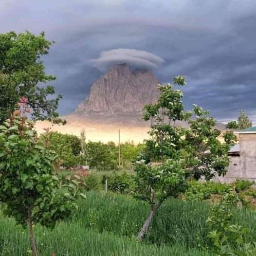
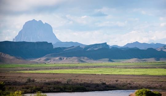
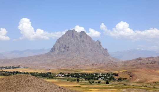
Ilanly Mountain, Hacha Mountain are also the bearers of holiness in the territory of Nakhchivan!
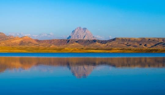
That Ilanly mountain is at a height of 2400 m above sea level!
When we say sea level, in Geographical Science we consider the Baltic Sea as a “zero” point, therefore, how many meters above sea level are calculated how many meters above sea level are depressions!
The interesting thing is that the Ilanly mountain area is a drought area!
The Cross of that mountain is called Yahar (“saddle”)!
Springs flow above the middle level of the mountain!
The strangeness is that the amount of spring water does not exceed, that is, the spring water that has been on that mountain for thousands of years does not flow to the foot of the mountain!
That is called the quantity!
That spring, that water carries a special order!
As example of this ”water order“ there is the ”Tandir spring“ in the south – west direction, not far from the sanctuary, at the bottom of the sanctuary of the sacred Yeddi Kimsanalar in Arabic sources ”Ashabul Kahf” (meaning: “Asaba” – man, “Kahf” – Cave), located on the left side of the Hacha Mountain (North)!
Although “Tandir” spring is actually a spring, it is named “Tandir” (tandoori) because it is round!
The surrounding area of Nahajir (meaning: “Noah opens”) plain is a waterless area.
The water source, located very close to the Yeddi Kimsanalar (Seven Inhabitants), is much larger than the diameter of tandoori, and the amount of water inside it is as if breathing!
The water rising from the deep layers of the Earth, rises to the edge of that circle, it stops a little while before pouring to the edge of the tandoori, and returns to the inside of the tandoori again!
It takes about ten minutes for the water to boil again, and it rises from the deep layers of the Earth to the edge of the tandoori, stops and recedes into the depths!
The height of the edge of that tandoori from the surface of the Earth is somewhere up to twenty centimeters!
But people manage to take that water into containers of different capacities, drink it while the water is drawn into the deep layers, and wash their hands and face!
As the water coming from the deep layers is so pure in taste, there are no salt compounds, a person washing hands and face there becomes lighter, frees from some blocks, relaxes, instantly moves away from the hustle and bustle and worries, a strange comfort envelops a person!In general, the sanctuary of Yeddi Kimsanalar is not far from the city of Nakhchivan!
You can get to Yeddi Kimsanalar by turning the motorway to the left to Julfa (South)!
After a little while when the road starts to the direction of Yeddi Kimsanalar, the amphitheater of holiness is felt in front!
On the left there is the Pirjuvar Nahajir plain, on the front there is Yeddi Kimsanalar Sanctuary, on the right there is the Ishigli Ilanly Hacha mountain, behind them (East) there is the Gami Gaya, and when you stand opposite to them on the back there is the Aghri Mountain. Being surrounded by a Ishigli mountain, surrounded by holiness, you fall into the comfort of the deep antiquity!

Although the area of Yeddi Kimsanalar, Ilanly Hacha mountain is drought!
But the water that rises in the tandoori from under the ground in the territory of Ilanly Mountain and Yeddi Kimsanalar, and the most interesting, the water springs in the hard mountain rocks in the height of Ilanly Mountain and Hacha Mountain tell us that a very powerful underground river flows from the underground layers of Nakhchivan territory!
That river crosses the southern hemisphere of the Earth from the Equator line, and the underground rivers of the entire Southern Hemisphere create communication with water between each other!
Holy water informing us about the interconnection of underground rivers and above-ground sanctity, and by giving water signs to Mountain Peaks with tandooris, warns us, the Earth people, of Holiness!
Vahid Rzaev.
More from my site
 The Greatest Genius…
 The Goat Symbol in Antique Nomadic Rugs
- A Forgotten Sufi Symbol in Safavid Carpet Art
 Definition, restoraton and multilingual comparative analysis of the initial form of Azerbaijani language’s lexical base
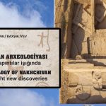 Archaeology of Nachchivvan in the light new discoveries
 Summary to grow plants Khayala Ramazanova